
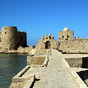
Kinematics of the Lebanese restraining bend: a key for understanding the Levant faultCampus France supports French research in its development strategy. One of its missions is to promote and develop the excellence of French research with students and researchers from around the world. In the framework of the Hubert Curien Partnerships (PHC), supported by Campus France, the EARTHQUAKES team of the Geoazur laboratory proposes to better characterize the kinematics in Lebanon, by improving quantitative knowledge of the regional velocity field, of the fault slip rates and more particularly of the compressive component across the restraining bend. Those research works are in line with previous international research programs conducted in Lebanon: ANR LIBRIS 2010-2014; PHC Cèdre 2016-2017; and the threefold cooperation between M. Vergnolle (Geoazur, Nice Sophia) – C. Lasserre (Laboratoire de Géologie de Lyon) – M. Brax (National Council for Scientific Research, Lebanon | CNRS Center for Geophysics). |
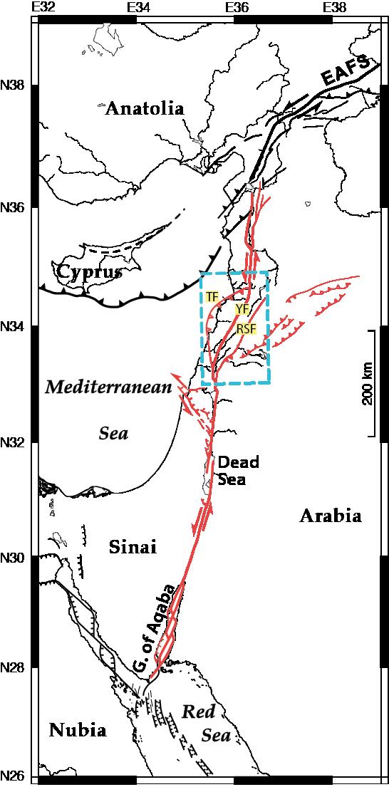
The Levant fault system extends over more than 1000 km from the Gulf of Aqaba in the Red Sea to Turkey. It is the plate boundary between the Arabian and Sinai plates and thus accommodates the differential movement between these two plates. This transform fault is mostly left-lateral and N-S on its northern and southern parts, but forms a transpressive restraining bend in its central part in Lebanon, associated with several strike-slip and reverse strands connected by lateral ramps (Gomez et al., 2003, Daëron et al., 2004, 2005,2007, Elias et al., 2007). Two main enigmas still exist to understand the behavior of this plate boundary and the associated deformation:
- The first enigma concerns the discrepancy between the (geological) displacement accommodated by the fault on its southern part (Gulf of Aqaba - Hula Basin, ~ 105km) and that accommodated on its central and northern parts (Lebanon, Syria, 20-30km e.g. Freund et al., 1968, Chaimov et al., 1990).
- The second enigma concerns the partitioning of the deformation between shear and compression. These two enigmas are related to the lack of quantification of compressive deformation and off-main fault deformation, especially in Lebanon and in the Palmyrids in Syria.
We first propose to combine different measurements of spatial geodesy to obtain the best possible spatial and temporal resolution of the instantaneous deformation in this region, including GNSS data analysis (remeasurement of the campaign network, processing of the campaign and the Lebanese-French continuous data, combination with available regional data) and the combination of the resulting GNSS velocity field with the InSAR velocity field produced within the overall project. We will be able to participate in the analysis of additional SAR data acquired in the area.
Secondly, we aim at implementing a model of deformation accommodation within the Lebanese restraining bend taking into account the complexity of the fault system and the associated uncertainties. This will answer the second enigma. Finally, a kinematic model of the Sinai plate constrained by the previous results will allow a better understanding of the organization of the deformation in the region and thus answer the first enigma. These results will be essential to better assess the regional seismic hazard.
The EARTHQUAKES team of the Geoazur laboratory is a multidisciplinary team combining skills in geodesy, tectonics, seismology, and modeling. It will collaborate with researchers from the Geology Laboratory of Lyon TPE and the Geophysical Research Center of the Lebanese CNRS in Lebanon in the framework of the International Associated Laboratory O-LIFE II (Lebanese-French Observatory of the Environment). Field missions of a few weeks in Lebanon are planned both for the remeasurement of the GNSS campaign network and for the monitoring of the recently installed permanent GNSS network (2016-2017).
Conference Proceedings:
Lasserre C., B. Pinel-Puysségur, M. Vergnolle, C. Voisin, Y. Klinger, M.-P. Doin, E. Pathier, D. Abdel-Massih. Present-day deformation in Lebanon measured by Synthetic Aperture Radar Interferometry (InSAR), Actes du colloque "Risque sismique : Aleas, Vulnérabilités et incertitudes -Liban et pourtour méditérannéen-", Beyrouth (Liban), 18-20 Novembre 2014, Géosphères, Annales de Géographie, 36, 25-32, 2015.
International Conferences:
Vergnolle M., Jomaa R., Brax M., Menut J.L., Sursock A., Elias A.R., Mariscal A., Vidal M., Cotte N., 2016. GPS Measurements of Crustal Deformation in Lebanon: Implication for Current Kinematics of the Sinaï Plate, Abstract G32A-05 presented at 2016 Fall Meeting, AGU, San Francisco, Calif., 12-16 Dec., 2016.
Vergnolle M., al., 2013. New constraints on the Sinai kinematic plate from a consistent Levant fault velocity field integrating new GPS data in Lebanon, 1174 Abstract, Tectonics of the Levant fault and northern Red Sea workshop, Paris, IPGP, July 2013.
Lasserre C., B. Pinel-Puysségur, M. Vergnolle, Y. Klinger, E. Pathier, 2013. Active faults in Lebanon: kinematics and interseismic behavior measured from radar interferometry (InSAR), 1165 Abstract, Tectonics of the Levant fault and northern Red Sea workshop, Paris, IPGP, July 2013.
Vergnolle M., R. Jomaa, A. Elias, A. Sursock, Y. Klinger, A. Mariscal, E. Jacques, N. Cotte, 2012. Lateral and across fault slip rates from new GPS profiles across the Lebanese restraining bend, AGU Fall meeting 2012.
Lasserre C., B. Pinel-Puysségur, M. Vergnolle, Y. Klinger, E. Pathier, 2012. Active faults in Lebanon: kinematics and interseismic behavior measured from radar interferometry (InSAR), Abstract G51B-1103, Fall Meeting, AGU, San Francisco, Calif., 3-7 Dec, 2012
 |
 |
|
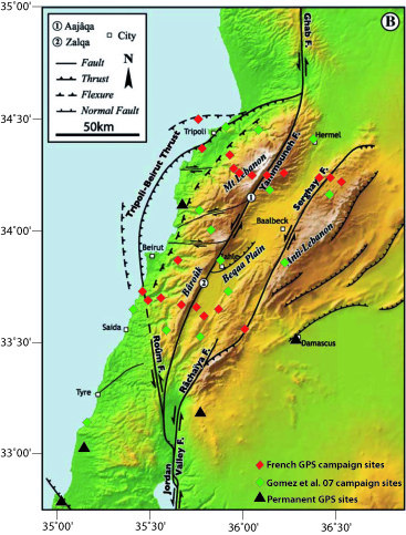
| Fig. Tectonic context of the Levant fault system. TF: large thrust system off Lebanon, YF: Yammouneh fault, main branch of the Levant fault in Lebanon, RSF: Rachaya-Serghaya fault system in Lebanon. | Fig. Tectonic context of the Levant fault system in Lebanon (from Daeron et al. 2004) and location of GPS sites. |
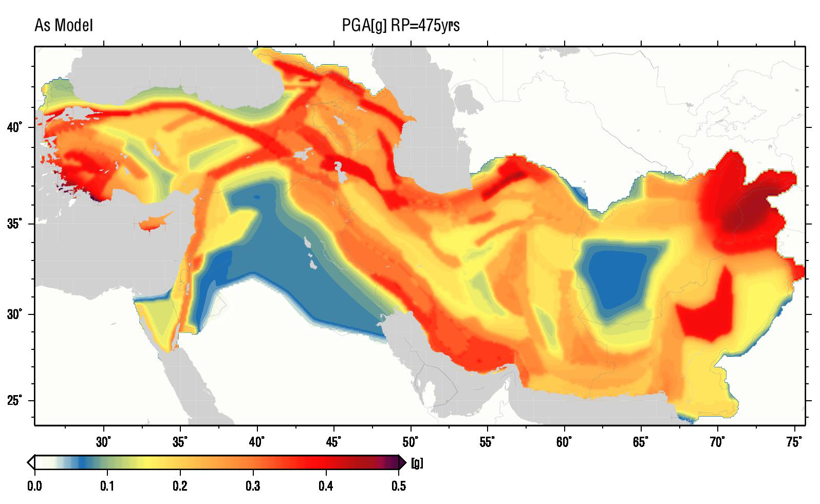
Fig. Probabilistic seismic hazard map: average values of acceleration horizontal to PGA, that have a 10% chance of being exceeded for 50 years (return period 475 years).
According to EMME (Sesetyan et al. 2014), http://www.globalquakemodel.org/what/regions/middle-east/).