
Flagship Research Projects
{imageshow sl=23 sc=6 w=800 h=400 /}

MEGA - Giant submarine landslides in gas hydrate provinces: a comparison of the Nile and Amazon deep-sea fan - ANR 2023 (2)
- Details
Giant submarine landslides (10-2000 km3) are found in the thick Quaternary sediment succession of passive continental margins. Their ages coincide with periods of sea-level fall and rise, but it is unclear how such vast failures can be triggered on low seafloor slopes (<2˚) in the absence of a triggering factor such as seismicity. Key hypotheses involve excess pore pressures linked to reductions in gas-hydrate stability, driven by changes either in climate or in subsurface fluid flow. The MEGA project wants to explore such hypotheses through the first modelling of linked changes in gas hydrate and slope stability in response to ocean pressure and temperature changes, using an innovative comparison of the Nile and Amazon deep-sea fans that experience different forms of climate forcing over glacial-interglacial timescales. As such megaslides have never triggered in historical times, MEGA will provide input for the first modelling of their tsunamogenic consequences on coastal zones.
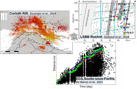
INSeiS - Induced seismicity and natural swarms: a universal mechanism? - ANR 2022
- Details
Fluids induce earthquakes both in the form of natural swarms and when geological reservoirs are exploited. In both cases, seismicity can either stop on its own or represent the precursors of major earthquakes. For our own safety in the face of seismic risk and for the safe development of new energy sources, it is therefore necessary to anticipate the evolution of seismic swarms, which means monitoring their mechanical forcing. However, the complex interactions between fluids, slow and asismic deformations and earthquakes are complex and still poorly understood. The INSeis project is motivated by new models that reconcile these phenomena. Its aim is therefore to improve our understanding of the processes that generate seismic swarms in different contexts and on different scales, in order to improve the forecasting of swarm behaviour.
ABYSS - Monitoring giant subduction faults using distributed acoustic measurements on the seafloor - ERC 2022
- Details
The objective of the ABYSS project is to probe the mechanical state of a fault zone prior to several large earthquakes (magnitude > 6) in order to identify systematic markers of the earthquake preparatory phase. The chosen target is one of the most active faults on Earth: the Chilean subduction zone. A promising technology will be used, the distributed acoustic measurement on optical fibers, which allows to detect earthquakes thanks to underwater telecommunication cables. ABYSS will rely on the GTD network along the Chilean coast. This unprecedented observation capability, combined with the development of real-time data stream processing, will strengthen the early warning system in Chile by improving the speed and accuracy of seismic warnings.
- HOPE - HOw Predictable are Earthquakes - ERC 2022
- OSMOSE - tOward a multi-stakeholder Socio-seisMological Observation network for Seismic risk rEduction in Haiti - ANR 2022
- LisAlps - Probing the 3D Alpine lithosphere by Full Waveform Inversion of the AlpArray teleseismic data - ANR 2021
- NILAFAR - The NILE & AFAR areas: hydrological change sensitivity and impact on past human adaptation since 20,000 years
- EARLI - detection of Early seismic signal using ARtificiaL Intelligence - ERC 2021
- WIND - Waveform Inversion of Node Data - Consortium 2020
- S5 - Synchronous Slow Slip & Seismic Swarm
- MARACAS - MARine terraces along the northern Andean Coast as a proxy for seismic hazard ASsessment - ANR JC 2018
- Com2SiCa - Understanding and Simulation of Human Behaviors in areas affected by disasters: from analysis to policy making
- FAULTS R GEMS - Properties of FAULTS, a key to Realistic Generic Earthquake Modeling and hazard Simulation
- INPOP and the Search of the Planet P9
- REMAKE - Seismic Risk in Ecuador: Mitigation, Anticipation and Knowledge of Earthquakes
- SISMED - Seismic Imaging inveStigation in MEDiterranean Sea for deep seismogenic faults
- E-POST - The Early POSTseismic Deformation
- HYDROSEIS - Role of fluids and fault HYDROmechanics on SEISmic rupture
- OBSIVA - Virtual Seismological Observatory for the Lesser Antilles Subduction
- TO-EOS - The Tohoku-Oki Earthquake from Earth to Oceans and Space
UMR Géoazur
Campus Azur du CNRS
250 rue Albert Einstein
- CS 10269 - F 06905 SOPHIA ANTIPOLIS Cedex
+33 (0)483 618 500

![]()
![]()
![]()